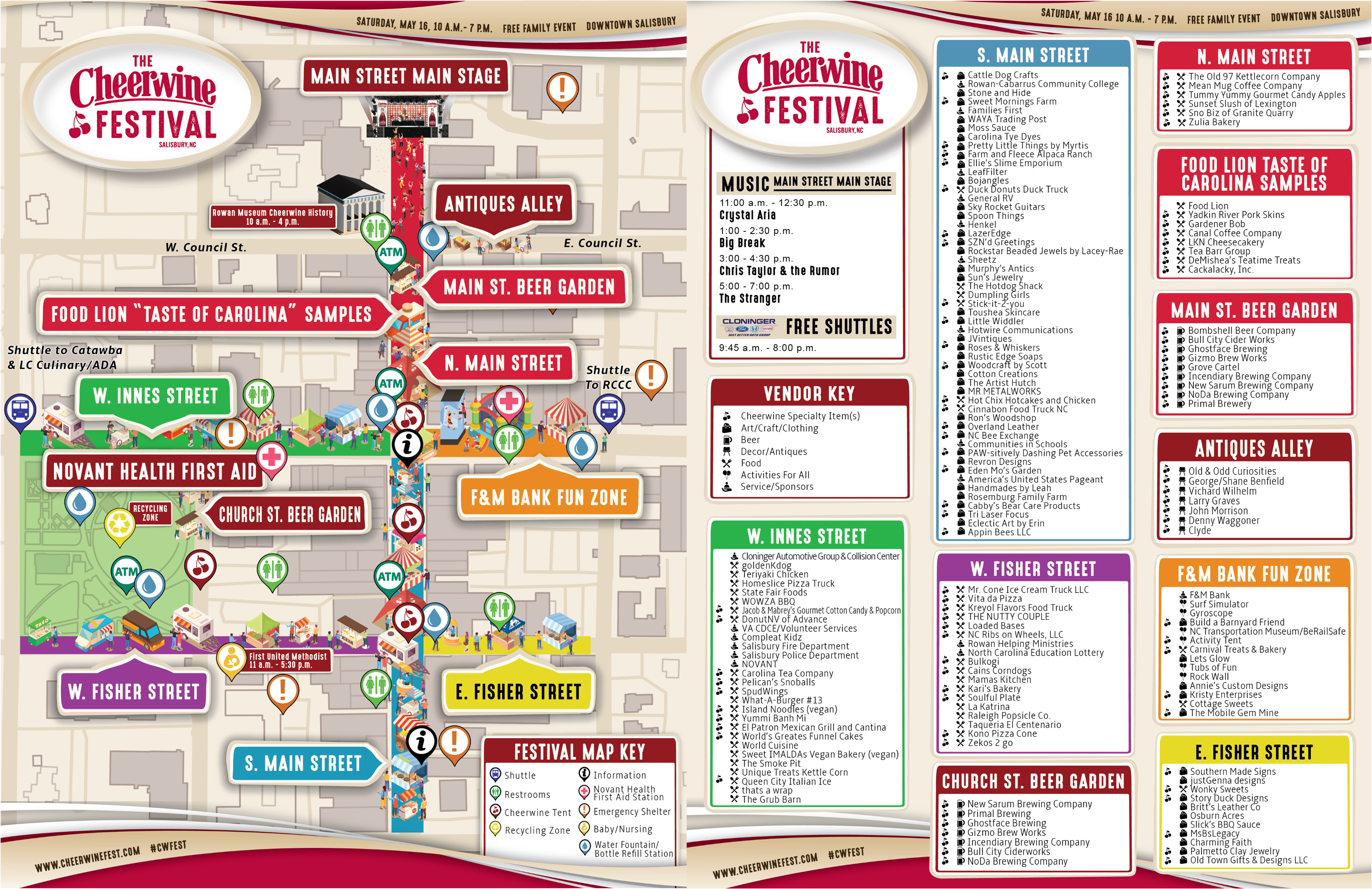
Festival Map
We have over one hundred and fifty food, craft and beer vendors participating in this year's Cheerwine Festival. Plan ahead by reviewing the festival map.
Festival Map (PNG)

TRANSPORTATION SPONSOR
Cloninger Automotive Group & Collision Center is proud to sponsor your transportation needs for the 2026 Cheerwine Festival.
Shuttles Map
Shuttle stop locations are included on the festival map. Signage will be used to guide drivers to the offsite shuttle parking. The free shuttles run from 9:45 a.m. to 8 p.m., arriving approximately every fifteen minutes.
Shuttles Map (PNG) Shuttle Map (Google)
Shuttle Locations:
- Catawba College, 2300 W Innes St, Salisbury, NC 28144
- Rowan-Cabarrus Community College, 1333 Jake Alexander Blvd S, Salisbury, NC 28146
- ADA/Handicapped: The Livingstone College School of Hospitality Management and Culinary Arts, 530 Jake Alexander Blvd. Salisbury, NC 28144
- Overflow ADA/Handicapped parking available at Rowan-Cabarrus Community College, 1333 Jake Alexander Blvd S., Salisbury NC 28146
NC by Train
Ride NC By Train to the annual Cheerwine Festival. With a modified schedule and multiple daily departures, it's easy to plan a day trip and enjoy one of North Carolina's most iconic celebrations. The Salisbury Station is located within walking distance of the festival, so you can step off the train and head straight into the event.
Special Schedule for May 16:
- Schedules have been adjusted to better align with festival hours
- All trains will stop in Salisbury throughout the day
- Piedmont Train 77 will also stop in Kannapolis to improve connectivity
Train Ticket
Parking Map
For those not using the free shuttle system, free parking is available in multiple locations around the festival in Downtown Salisbury. Handicap/ADA parking has been designated at 231 S. Main St. and 310 N. Main St.
Parking Map (PNG)
Parking Map (Google Map)
Road Closures
Friday, May 15, 2026
4:00 p.m.
- 200 block of N. Main St. between Council St. and Liberty St.
10:00 p.m.
- 100 block of N. Main St.
- 100 & 200 blocks of S. Main St.
- 100 block of E. & W. Council St.
- 100 block of E. Fisher St.
- 100 & 200 blocks of W. Fisher St.
- 100 blocks of N. & S. Church St.
- 100 block of S. Jackson St.
Road Closures Map (PNG)
Map to Salisbury, NC
Salisbury, NC is the seat of Rowan County and is conveniently centered in the prosperous North Carolina Piedmont region between the Charlotte metro and the Greensboro and Winston-Salem areas, just off of Interstate 85.